
Maps can lead to questions about the history of the area where your ancestors lived. Various types of maps of Denmark have been drawn over the years and each serves a different purpose. Cadastral maps are a good source when researching an ancestor's real property, whereas parish maps can provide context for the family history.
My great-great-grandfather Thomas Jensen Juhl (1864-1949) owned a farm in Nørre Holsted, Holsted Parish, Denmark.1 In this map of Holsted Parish, his land is highlighted in green.2 The towns Nørre Holsted and Sønder Holsted are circled in blue with the parish church just outside town.
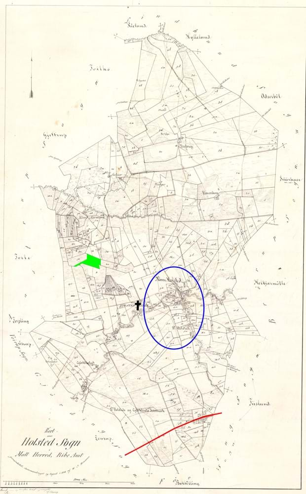
The red line at the bottom of the map shows the railroad, which was established in 1874. The railroad ran about 1.2 miles south of the two towns, but soon a new town grew around the station called Holsted Stationsby, which means railroad town. Per a local historian, this development led to animosity between the residents of the old towns and those in the railroad town.3 I would have liked to ask my grandmother Jenny Kirstine Juhl (1921-2008) about that and get her perspective on it, but I did not learn about the railroad history until after she passed away.
If you still have your grandparents, remember to ask them about such things. Show them an old map to trigger their memory, and they may tell you stories which you cannot find at the archives.
Source references:
- Frederik Peter Juhl to Thomas Jensen Juhl, deed for land and buildings at lot numbers 9b and 12b in N. Holsted, 30 October 1890; Lokalhistorisk Arkiv Holsted [the local archives for Holsted].
- W. J. Branner, Kort over Holsted Sogn i Malt Herred, Ribe Amt [Map of Holsted Parish in Malt District, Ribe County] (1844); image copy, Geodatastyrelsen, Historiske kort på nettet (https://hkpn.gst.dk/mapviewer.aspx?type=sognekort&id=2841 : accessed 12 February 2022). This type of map was updated regularly.
- Charlotte Thomsen, HistorieVejen (https://historievejen.inst.vejen.dk : accessed 12 February 2022) > Historie > Stationsbyer og industri > Stationsbyerne > Holsted; citing Linda Klitmøller, "Vejen, Brørup og Holsted - tre sydvestjyske stationsbyer," (Museet på Sønderskov: 1998).


